Description
Surface and ground water availability in East Africa varies substantially with time and climate, and across subregions. Climate, land use, and land management changes are key factors affecting the integrity of water resources, yet related data are generally insufficient, unavailable, or inaccessible for effective decision-making and management with respect to water resources.
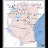
This dataset comprises precipitation and temperature data as available and shareable for selected locations in three East African countries—Kenya, Tanzania, and Uganda. Additional time series developed through bias correction of Climate Forecast System Reanalysis (CFSR, Saha et al., 2010) data are included and can be used in place of observed data where the latter are deemed insufficient for use in analysis.
The data can be used for hydrologic and water quality modeling or other water resources applications and are formatted for easy use with such applications. Detailed metadata are provided with the dataset.
Data for the following stations are included with the dataset:
Kenya
⦁ Garissa
⦁ Jomo Kenyatta International Airport (JKIA)
⦁ Mandera
⦁ Mombasa
⦁ Moyale
Tanzania
⦁ Mtwara
⦁ Mwanza
⦁ Tabora
Uganda
⦁ Arua
⦁ Entebbe
⦁ Jinja
⦁ Soroti
The data are packaged and deployed so as to be Findable, Accessible, Interoperable, and Reusable (FAIR) in accordance with open data FAIR Guiding Principles (Wilkinson et al, 2016).
Primary Data Columns:
- date: Calendar date (YYYY-MM-DD)
- prcpmm: Daily precipitation (mm)
- tmin_c: Daily Minimum Temperatures (degrees Celsius)
- tmax_c: Daily Maximum Temperatures (degrees Celsius)
Data Sources:
Observed Data (stationname_climate_obs): Retrieved from the National Oceanic and Atmospheric Association Climate Data Online (https://www.ncdc.noaa.gov/cdo-web/)
Original Reanalysis Data: Retrieved from National Centers for Environmental Prediction Climate Forecast System Reanalysis Versions 1 and 2 (https://doi.org/10.5065/D69K487J, https://doi.org/10.5065/D61C1TXF).
Funding Acknowledgement
This dataset was made possible in part through support provided by the Center for Development Research, U.S. Global Development Lab (Lab), U.S. Agency for International Development, through the LASER PULSE Program under the terms of Cooperative Agreement No. 7200AA18CA00009. The opinions expressed herein are those of the author(s) and do not necessarily reflect the views of the U.S. Agency for International Development.
Cite this work
Researchers should cite this work as follows:
- Garibay, V.; Gitau, M. W.; Kiggundu, N.; Moriasi, D.; Mishili, F. (2021). Precipitation and Temperature Data for Select 12 Stations in Kenya, Tanzania, and Uganda (1979-2020). Purdue University Research Repository. doi:10.4231/2YMW-JY19
Tags
Notes
Version 1 of January 15, 2021
The user is responsible for evaluation and use of the data. The authors make no warranties and are not liable for any errors arising out of or in connection to access or use of the dataset and associated materials.
